

2. Site description
2.1. Location and its Environmental Characteristics
1) The project is situated in a geographic context encompassing Mount Lu, Boyang Lake, and China’s so-called “Fourth Pole of Economic Development”. A visual explanation of this contextual information is helpful to the harmony and integration with the larger environment (Figure 1).

Figure 1. Relationship of Ruichang, the project site, to the four major cities of the “Fourth Pole” of the new Chinese economy. Further to the east is the Yangtze Delta economic zone led by Shanghai.
2) One of the holiest mountains in China, Mount Lu is revered by millions not only for its stunning beauty, but also for its cultural heritage.A UNESCO World Heritage Site, Mount Lu attracts more than 10 million visitors annually. The project site is approximately 40 km west of Mount Lu. In 2016, the new Mount Lu High-speed Train Station will be completed at about 2 km distance from the project site and expected to handle more than 3 million visitors to Mount Lu annually. MOLEWA and Flower Ocean, aside from benefits to the local residents, seek to inspire this visitor populationto experience new leisure and cultural activities.
Mount Lu and its environs contain some of China’s richest architectural treasures. The early missionaries from America and Europe constructed hundreds of 19th century-vintage villas. Roughly 250 km to the East is the Wu Yuan village, which is one of China’s most well-preserved and architecturally distinguished sites of traditional rural dwellings.

Figure 2. Mount Lu and its architectural heritage.
3) The Poyang Lake, about 60 km to the southeast of the site, is China’s largest freshwater lake and one of the world’s largest bird habitats which welcomes millions of peregrines in the fall. The Lake has China’s largest Wetland National Park and boasts an impressive bio-diversified ecosphere that is, however, threatened by some unscrupulous development.
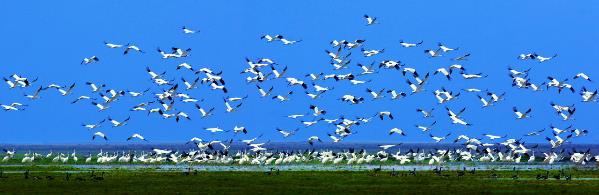
Figure 3. Poyang Lake is home to China’s largest wetland national park and supports a great variety of birds.
2.2. Population Reach of the Project
1) Wuhan (at 200 km), Nanchang (at 140 km) and Jiujiang(at 36 km) are the major cities near the site, with populations of 12 , 8 and 7 million, respectively.
2) The city of Ruichang, where the project is located, enjoys the remarkable geographic advantage by its centrality in the “Fourth Pole” comprised of Wuhan, Changsha, Nanchang and Hefei (see Figure 1). With a population over 100 million, the Fourth Pole is seen as China’s new economic engine as its export-driven economy shifts inland.
3) The above factors supported the decision to initiate a project aimed to promote new urbanization through cultural tourism in Ruichang and should be taken into account by the contestant during the design process.
2.3. The City of Ruichang
1) The city of Ruichang in northern Jiangxi province, where the project is located, is a medium-sized city representative of the state of development of formerly rural regions in China. It has a population of 450,000 and an area of 1,440 square kilometer.
With a GDP of 11 billion CNY in 2012, Ruichang has a rather representative balance of workers in agriculture (60,000), manufacturing (97,000) and services (91,000).
Because of its location, population size, and state of overall socioeconomic development, the city is considered as an ideal place to experiment with an inspired model of new urbanization, a vision encapsulated in the project brief.
2) The general climate of Ruichang is subtropical, with well distinguished seasons, and soil condition which supports a great variety of growths. The annual rainfall is about 1200 mm, and March to July rainfall account for the more than half the annual amount. The coldest month is January, with an average temperature of 4.2 °C; the warmest month is August, with an average temperature of 31.1 °C. (All data are for 2013.)
The city topography is flat but surrounded by low mountain ranges. The city is situated on the south shore of the Yangtze River and is an important node of transport featuring several highways, railways, and aport.
The city is free from the threat of major natural disasters, with no earthquake or flooding of note recorded during the past half century.
2.4. Project Site: Datang New District
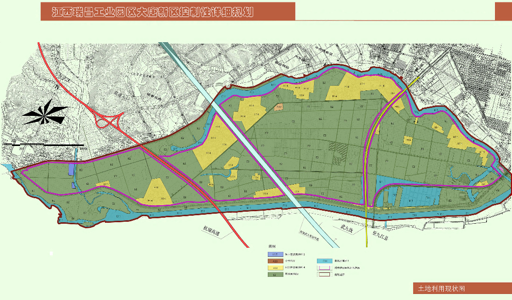
Figure 4. The old master plan for the Datang district. The “Flower Ocean /Huayan Township” project site is the portion east of the railway and its master plan has since been supplanted by the new design in Figure 5. This figure is used mainly to indicate the project size, road connections and relationship with the old city core (to the north).
1) The project site is part of the planned development called Datang New District, with a central geographic coordinate (29.6608°N, 115.6728°E). The old master plan for the Datang district is given in Figure 4.
2) As a consequence of the negotiation between the Project Investor and Local Government, the planned use and road connections within and around the project site have been modified, and the updated zoning providedin the masterplan information contained in this brief.
2.5. Constraints of the Site
1) The site is approximately triangular in shape, bounded by the Jiujiang-Nanchang Railway on the west, the Outer River on the south and Inner River on the north.
2) The railway places a constraint on the master plan, as high-value commercial development must be at a distance from the tracks.
3) The two rivers have relatively low water table, and large-scale modification of the water system would be cost-inhibitive, as well as subject to national anti-flooding regulations regarding the Yangtze River.
4) The underground water level is high, making large-scale underground earthwork impractical.